Roads in Ancient Israel
(Enlarge)
(PDF
for Print) (Freely Distributed)
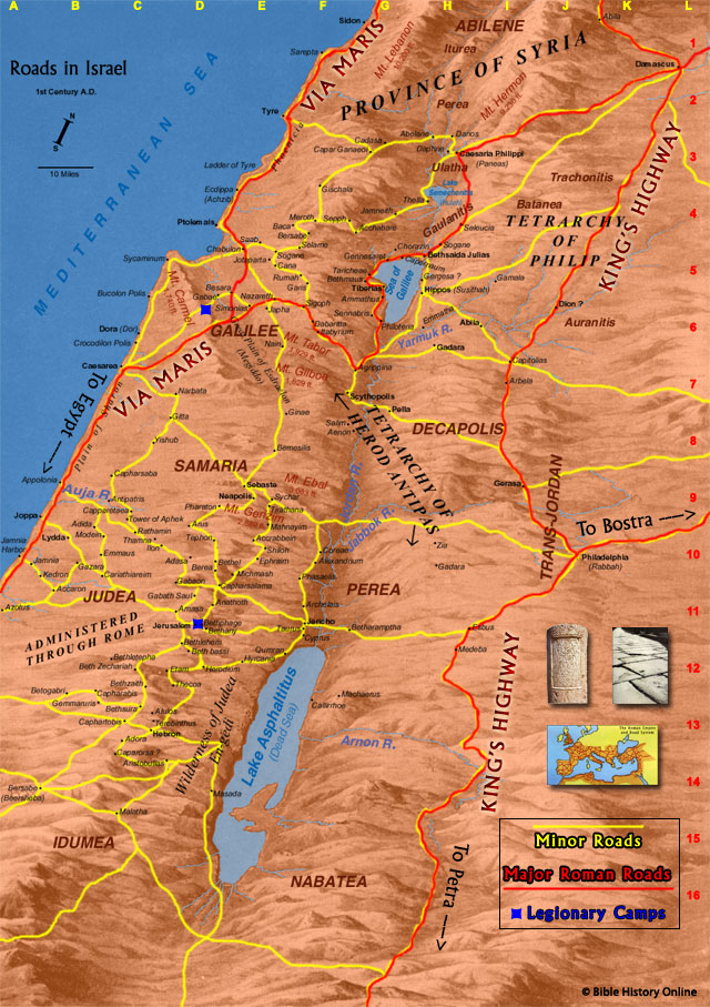
Map of the Roads in First Century Israel
This map includes general roads and Roman paved roads in ancient Israel. You can see the major and minor roads and highways, and the Roman Legionary Camps in the land of Israel during the first century AD. The Via Maris, the King's Highway, the Way of the Sea, and other small roads can be seen on this map.Proverbs 16:17 - The highway of the upright is to depart from evil: he that keepeth his way preserveth his soul.
Highways in Ancient Israel
In ancient Israel most people traveled on foot and israel was a
difficult place to travel. The highways and roads connected
travelers to the 6 parallel divisions in the topography, Israel's
cities and villages, the Dead Sea, and the Negev. The Hebrews
generally followed their small roads but they were not into major
road construction as the Romans were. In fact the Hebrew word for
road means a beaten worn out path. Road construction would have been
difficult for any skillful engineer because of the topography of the
land. When Jesus journeyed from Jerusalem through the land of
Samaria (John 4) there were no special roads but large dirt paths
with some stone. As He journeyed around Nazareth and the surrounding
villages in Galilee He was following beaten dirt tracks, with little
road making.
The Romans were skillful road makers who made the great highways of the Empire, so that soldiers and horses could travel on them. Most of the travelers along Roman highways were caravans, camels, horses, and donkeys.
The roads in first century Israel in
the time of Jesus were as follows:
1. The road that passed northward up the coastal plain from Gaza,
(the port of the Egyptian desert), past Joppa and Caesarea round the
nose of Mount Carmel up to Tyre, and Sidon. This road, at a point
due west of Jerusalem, had a fork running north-eastward, climbing
the foothills of Samaria and going through the valleys of Samaria
(including that in which Joseph was sold to the Egyptians) to the
plain of Esdraelon. Crossing that plain it climbed the Galilean
hills and passed between two strange rocky peaks called the Horns of
Hattin down a ravine in which dwelt thousands of pigeons that were
captured in Jesus' day to be sold in the Temple for the poor to use
as sacrificial offerings. Then to the Plain of Gennesaret which the
road then crossed, and north through Capernaum and crossing the
Jordan with Mount Hermon on it�s left, eastward to Damascus.
2. Starting in the south from Beersheba (the other port of Palestine
on the Egyptian desert), a very ancient road climbed northward up
the Judean hills to Hebron and through Bethlehem to Jerusalem. The
Flight into Egypt from Bethlehem with the infant Jesus would
probably take this route. From Jerusalem the road forked in three
directions. One ran to the left down the steep ravines of the Judean
hills to the coastal plain and to Joppa. It is down this road that
Peter would go in the journey described in Acts. The road to the
east ran even more steeply down past Bethany to the deep trench of
the Jordan valley. This is the road from Jerusalem to Jericho (a
descent of 3500 feet in 14 miles) that is the scene of the story of
the Good Samaritan; and up its steep slopes Jesus came from
Transjordania, the Jordan Valley, and Jericho, to face trial and
death at Jerusalem.
3. Another road from Jerusalem ran directly northward over the hills
of Judea, passing by the site of Bethel and descending into a small
plain before lifting again to the hills of Samaria under the shadow
of Mount Gerizim and Mount Ebal. Through Samaria it runs past the
foot of Mount Gilboa across the Plain of Esdraelon, where one fork
runs north-westward to Nazareth and another north-eastward by the
foot of Mount Tabor and the north end of the Lake of Galilee, where
it joins up with the great Way of the Sea. It will be seen that none
of these roads to and from Jerusalem is a great international
highway. The roads or tracks are there because Jerusalem exists; and
they simply lead to and from the Holy City.
4. Moving still farther east we come upon another series of routes
important in the life of Jesus. The Gospels tell us that He took the
road from Galilee to Jerusalem through Samaria on at least one
occasion. The fierce hostility of the Samaritans to the Jews,
however, led Jews when traveling from the north to Jerusalem to turn
eastward at Jezreel (the eastern gap from the Plain of Esdraelon
into the Jordan Valley), and go down into that valley to join a road
running southward on the western side of the river to Jericho. There
the pilgrims to Jerusalem would turn west again to climb up to
Jerusalem, having avoided Samaria.
5. Still farther east, on the Transjordania side of the Jordan
River, roads ran in Jesus' time between the Graeco-Roman cities of
Decapolis. It is highly probable that in His last journey
(associated in Luke with the parables of the lost money, the lost
sheep, and the prodigal son) Jesus walked upon these roads, which
ran through Philadelphia, Gerasa, Gadara and up to Damascus. The
road from Amman also ran southward. Jesus did not take this road;
but as it ran near to the Castle of Machaerus, in which Herod
Antipas imprisoned John the Baptist, John himself may have been led
in chains along that route.
Merchants and Trade
During the first century A.D. the East
and West were making a solid connection, especially with the Jews.
By the time of Jesus the Jews were living in a commercial Greek
world, due to the achievements of Alexander the Great. The Romans
built even more and established additional trade in all of its
provinces, linking the major centers of population and uniting the
provinces. The Mediterranean world had become a Greco-Roman world
and it had become like one big marketplace, attracting trade goods
from distant lands as far as India and China. The Roman army and
navy protected the boundaries of the Empire from barbarians and
pirates.
The Jews had become very familiar with trade and the art of
international commerce. They became very wealthy and it was all
controlled by a select few. Most of the common Israelites bought and
sold in the local marketplace without ever realizing how all the
goods from around the world had arrived there. How many of the goods
had arrived there on the backs of camels and donkeys, passing
through countless cities and villages upon roads and footpaths that
were all but washed away by the heavy rains.
There were many roads that criss-crossed all of Israel, roads that
had been there for hundreds of years and when the legions of Rome
came they had built up certain highways to march their mighty
chariots and soldiers. The main roads contained 3-foot deep bed,
paved with gravel, stones and concrete. They were built to last and
made life much easier for the many caravans of merchants in the
ancient world. Some of these roads can still be seen today.
Milestones marked the roads with their drainage ditches and curbs.
By the end of the first century 50,000 miles of roads linked the
Roman Empire with the whole Mediterranean world. The network of
roads made it safe to trade, for the first time in the history of
the world.
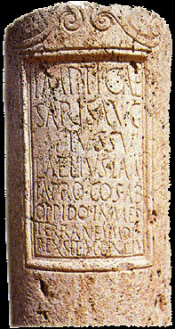 |
Milestones It has often been said, "all roads lead to Rome" and this was correct in the time of Jesus. Actually all roads led "from" Rome because the Roman Forum (Romanium) marked the starting point and every road was measured from it, from the gilded pillar that Caesar Augustus had placed there. The roads were clearly marked with milestones from the "Eternal City." No pilgrim or merchant could ever forget that he journeyed upon an imperial road. The Roman mile was 1500 meters or 1000 paces and it was marked with a milestone (Mille is Latin for 1000). |
The ancient Jews learned the art of commerce very quickly. They
became renown throughout the world as successful traders within and
without the borders of their country.
The Provinces - The Roman Empire beyond Italy was divided into about 40 provinces, or territories. Each province had its own governor, who was appointed by the emperor or named by the Senate. The governors' work mainly included keeping order and collecting taxes. Augustus and the emperors who followed him expanded the empire by conquering new territories. By the end of the first century A.D. the Roman Empire had a population of about 60 million. This was more than one-fifth of the total population of the world at that time.
The Pax Romana - Augustus's
reign marked the beginning of a remarkable period in Rome's history.
For more than 200 years, the vast Roman Empire was united and, for
the most part, peaceful. This period from 27 B.C. to 180 A.D. is
called the Pax Romana, or "Peace of Rome."
Roman Roads
By the time of Jesus the Romans had brought peace throughout their
Empire. The Mediterranean world had become a place of opportunity
for traders and merchants. The Romans developed a massive network of
roads that stretched over 50,000 miles throughout the Mediterranean
world. This made it relatively easy for the Roman army to move
quickly to defend its borders. Supplies could also be sent to the
troops over long distances. Along the roads were inns, restaurants
and hotels; places where horses were changed, or where weary
travelers could rest for the night and get food.
The Via Appia was the first of the marvelous Roman roads. It began
to be built in 312 B.C. and reached as far from Rome as Brundisium,
an Adriatic port.
In Israel there were 3 main roads, one of which was the Via Maris.
Paved Roads
Roman were experts at surveying and building roads. They would plan
out a strategic route and remove any obstacles in its path. Then
they would dig a trench about 3 feet deep and 10-25 feet wide,
depending upon the importance of the road.
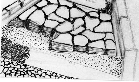
Illustration of a Roman Paved
Road
The 4 Layers
The deepest portion of the trench was filled in with a layer of
large stones tightly fitted together. This was strategic in
preventing puddles and keeping the roads from freezing, which caused
cracks.
The second layer was filled with smaller stones compressed together
and filled with concrete.
The third layer was filled with gravel and flattened out smoothly.
The fourth and last layer was a pavement of large smooth stone
slabs.
Every major road had curbs and drainage ditches.
The largest roads were in Rome and on its borders, to bring a sense
of awe to anyone from the outside. They sometimes reached 50 feet
wide.
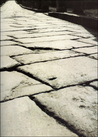
Photo of a Roman Road
Network of Roads in the
Roman Empire
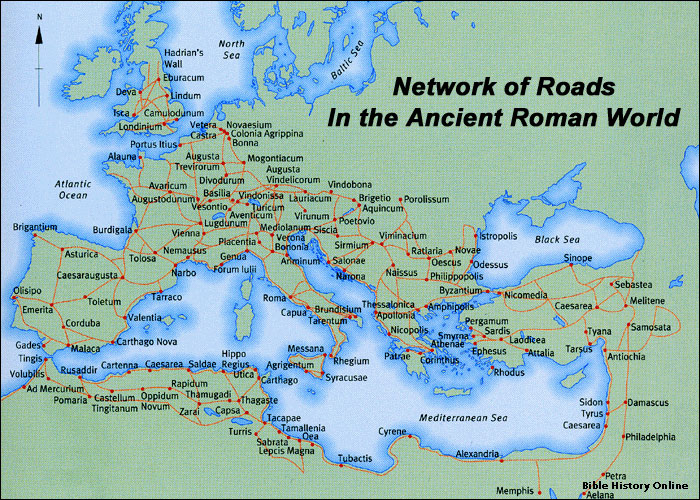
Network of Roads in the Roman Empire
Robbers and Thugs
During the time of Jesus it was very dangerous to travel in certain
parts of Israel. Even though there was added security in various
parts of the Empire, there were bandits that would lie in wait and
attack unsuspecting merchants. The wealthy merchants could be
noticed easily because their goods were packed high on the backs of
their donkeys and camels. Robbers were known to hide in the hills,
make their attack, and return to caves and other hiding places.
The ancient Jews learned the art of commerce very quickly. They
became renown throughout the world as successful traders within and
without the borders of their country.
The Land of Israel
The Province of Syria
Via Maris
One of the most important trade routes in the Middle East during
ancient times was the Via Maris. The Latin term, meaning "Way of the
Sea" is referenced in Isaiah 8:23 in the Tanakh (in the Christian
Old Testament it is Isaiah 9:1) as "Derech HaYam" or "Way of the
Sea." The Latin name comes from the Vulgate, the Latin translation
of the New Testament, in Matthew 4:15. The term "Via Maris" comes
from the Romans and hence the terminology "Via Maris" tends to be an
exclusively Christian reference to the Sea Road. Other names for the
Derech HaYam/Via Maris include "Coastal Road" and "Way of the
Philistines." From the coast to Damascus, the route is called the
Trunk Road. The Via Maris travels and is also known as the
International Coastal Highway. The International Coastal Highway is
still a major route in modern-day Israel.
The "Way of the Sea" is one of three major trade routes in ancient
Israel � the Via Maris, Ridge Route, and the King's Highway. It is
situated from the Galilee to the North to Samaria to the South,
running through the Jezreel Valley. At the Philistine Plain, the Way
broke into two branches, one on the coast and one inland (through
the Jezreel Valley, the Sea of Galilee, and Dan), which unites at
Megiddo ("Armageddon"). The location of Megiddo vis a vis the Via
Maris explains why Megiddo was a very important route for travel and
trading city in ancient Israel. The Way of the Sea connected the
major routes from the Fertile Cresent to Mesopotamia (from Egypt to
modern day Iran, Iraq, Turkey and Syria).The road was the main
thoroughfare running north/south from the Sinai along the coastal
plain through the Jezreel valley, Beit Shean and on until Damascus
Throughout the centuries, once the Jews were exiled from Israel, the
Jezreel Valley, in which the route traverses, became abandoned and
the area became an infested swamp. Zionist pioneers, however,
drained the swamp from the time of the first land acquisition in
1921, and the valley has been transformed into a fertile,
fruit-bearing plain.
King's Highway
The King�s Highway was a very ancient trade route that was important in Biblical times. The highway started in Egypt and went up through the Sinai Peninsula over to Aqaba and up the eastern side of the Jordan River to Damascus and the Euphrates River.
The King's Highway is mentioned in the
Bible in Numbers 20:17-21:
"Please let us pass through your country. We will not pass through
fields or vineyards, nor will we drink water from wells; we will go
along the King's Highway; we will not turn aside to the right hand
or to the left until we have passed through your territory.'" Then
Edom said to him, "You shall not pass through my land, lest I come
out against you with the sword." So the children of Israel said to
him, "We will go by the Highway, and if I or my livestock drink any
of your water, then I will pay for it; let me only pass through on
foot, nothing more." Then he said,"You shall not pass through." So
Edom came out against them with many men and with a strong hand.
Thus Edom refused to give Israel passage through his territory; so
Israel turned away from him. "
"Numerous ancient states, including
Edom, Moab, Ammon, and various Aramaean polities depended largely on
the King's Highway for trade. The Highway began in Heliopolis, Egypt
and from there went eastward to Clysma (modern Suez), through the
Mitla Pass and the Egyptian forts of Nekhl and Themed in the Sinai
desert to Eilat and Aqaba. From there the Highway turned northward
through the Arabah, past Petra and Ma'an to Udruh, Sela, and Shaubak.
It passed through Kerak and the land of Moab to Madaba, Rabbah Ammon/Philadelphia
(modern Amman), Gerasa, Bosra, Damascus, and Tadmor, ending at
Resafa on the upper Euphrates...The Nabataeans used this road as a
trade route for luxury goods such as frankincense and spices from
southern Arabia. During the Roman period, the King's Highway was
rebuilt by Trajan and called the Via Traiana Nova." - Wikipedia
Judea
It was King Herod�s goal to make Jerusalem the most impressive city
in the world. He would go to any means to impress the world with his
Hellenized buildings and magnificent Greek architecture.
Legionary Camps in Israel and the Province of Syria
"Tiles found in Caesarea Maritima, built in the second decade BC, suggest that the legion was at that time based in Judaea. Later X Fretensis moved to Syria. In 6 AD it was stationed in that province together with legions III Gallica, VI Ferrata, and XII Fulminata. In the same year, Publius Sulpicius Quirinus, governor of Syria, led these legions in the suppression of the revolt that sprung out after the deposition of Herod Archelaus. Under Nero, in 58-63 AD, X Fretensis participated in the campaigns of Gnaeus Domitius Corbulo against the Parthians. First Jewish-Roman War. Ruins of the city of Gamla, conquered by X Fretensis in 68 AD. X Fretensis was centrally involved in the First Jewish-Roman War (66�73 AD), under the supreme command of Vespasian. In 66 AD, the X Fretensis and V Macedonica went to Alexandria for an invasion of Ethiopia planned by Nero. However, the two legions were needed in Judaea to suppress a revolt. After spending the winter in Ptolemais Ace (modern Acre, Israel), X Fretensis and V Macedonica relocated in the coastal city of Caesarea Maritima (67/68). This was due to the large number of legions being mobilized in Ptolemais, under Marcus Ulpius Traianus, future governor of Syria and father of the emperor Trajan. During that same winter, the Caesarea camp of Xth and Vth hosted Vespasian, who was forced to go to Rome the following year, where he seized power. Vespasian's son, Titus finished the suppression of the revolt.
By 70, the rebellion in all of Iudaea
had been crushed, except for Jerusalem and a few fortresses,
including Masada. In that year X Fretensis, in conjunction with V
Macedonica, XII Fulminata, and XV Apollinaris, began the siege of
Jerusalem, stronghold of the rebellion. The Xth camped on the Mount
of Olives. During the siege, Legio X gained fame in the effective
use of their various war machines. It was noted that they were able
to hurl stones that weighted a talent (about 25 kg) a distance of
two furlongs (400 m) or further. The projectiles of their ballistae
caused heavy damage to the ramparts. According to Josephus (vol. III
of his history of Judaean war) Larcius Lepidus was the commanding
officer of the X Legion. The siege of Jerusalem lasted five months
and the besieged population experienced all the terrible rigors of
starvation. Finally, the combined assaults of the legions succeeded
in taking the city, which was then subjected to destruction." -
Wikipedia
Ancient Roman Roads
"When the fullness of time came, God brought forth His Son, born of
a woman, born under the law." (Gal 4:4)
The Roman road was the bloodstream of the empire. Merchants paid
taxes to Rome on all their transactions, and they needed the roads
to carry their goods to an ever-widening market. Legionnaires
marched upon them swiftly gaining efficient access to battle. In a
sense, the roads were funding and facilitating Roman expansion.
Yet God had a higher purpose. A new kind of merchant would soon be
traversing the entire Mediterranean area, not one who transports his
treasure to the city marketplace, but one who is a treasure, and who
carries true riches, - not to sell, but to give away freely. The
transforming good news of God�s forgiveness through Jesus the
Messiah was imbedded into the hearts of the Apostles and early
believers, and God prepared those roads for them to walk upon and
lead others into His path.
A new kind of soldier would be running these well built
thoroughfares to fight, - not flesh and blood, but a spiritual
warfare that would liberate entire civilizations from the bondage of
Satan�s tyrannical oppression and coercion, to a Kingdom ruled by
love, service and willing devotion.
Throughout history �the road� has provided an excellent metaphor for
life�s journey. With amazement, we can look back over the winding
grades of difficulty, the narrow pass of opportunity, the choice
between security or adventure, when our road divided and we had to
make the call.
Yes, all roads led to Rome, specifically the Forum, in the ancient
empire of old, where an Emperor judged the players in the arena for
their conduct before him. Our personal road will eventually and
inevitably cease at the throne of Almighty God. It is He who must
judge our travel upon this earth, in the blinding glory of His
eternal justice. Compelled by His love, He placed sin�s damning
penalty upon His Own Son, instead of us, so that we could freely
receive the "thumbs up!" from Him who loves us beyond all measure.
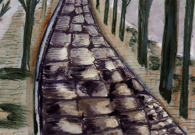
Painting of a Roman Highway
Highways in Smith's
Bible Dictionary
Highways
Though during the sway of the Romans
over Israel they made a few substantial roads for their carts and
chariots, yet for the most of the time, as today, the Jews had
nothing such as we call roads, but only footpaths through which
animals walk in single file. These are never cared for, no repairs
are made or obstacles removed. This fact brings into striking
prominence the figure of repairing a highway for the return Of the
captives, or the coming of the great King. On special occasions
kings had roads prepared for the progress of their armies, or their
own going from place to place. Full
Article
Roman Roads
in
the Bible Encyclopedia - ISBE
7. Cities of Galilee:
In material ways too Rome
opened the way for Christianity by building the great highways for
the gospel. The great system of roads that knit then civilized world
together served not only the legions and the imperial escorts, but
were of equal service to the early missionaries, and when churches
began to spring up over the empire, these roads greatly facilitated
that church organization and brotherhood which strengthened the
church to overcome the empire. With the dawn of the pax Romana all
these roads became alive once more with a galaxy of caravans and
traders. Commerce revived and was carried on under circumstances
more favorable than any that obtained till the past century. Men
exchanged not only material things, but also spiritual things. Many
of these early traders and artisans were Christians, and while they
bought and sold the things that perish, they did not lose an
opportunity of spreading the gospel. For an empire which embraced
the Mediterranean shores, the sea was an important means of
intercommunication; and the Mediterranean routes were safer for
commerce and travel at that period than during any previous one.
Pompey the Great had driven the pirates off the sea, and with the
fall of Sextus Pompey no hostile maritime forces remained. The ships
which plied in countless numbers from point to point of this great
inland sea offered splendid advantages and opportunity for early
Christian missionary enthusiasm.
Full Article
Highways in Easton's Bible Dictionary
Highway. a raised road for public use.
Such roads were not found in Israel; hence the force of the language
used to describe the return of the captives and the advent of the
Messiah (Isa. 11:16; 35:8; 40:3; 62:10) under the figure of the
preparation of a grand thoroughfare for their march. During their
possession of Israel the Romans constructed several important
highways, as they did in all countries which they ruled.
Full
Article
The Bible Mentions the "Highway" Often
2 Kings
18:17 - And the king of Assyria sent Tartan and Rabsaris and
Rabshakeh from Lachish to king Hezekiah with a great host against
Jerusalem. And they went up and came to Jerusalem. And when they
were come up, they came and stood by the conduit of the upper pool,
which [is] in the highway of the fuller's field.
Isaiah
19:23 - In that day shall there be a highway
out of Egypt to Assyria, and the Assyrian shall come into Egypt, and
the Egyptian into Assyria, and the Egyptians shall serve with the
Assyrians.
Judges
21:19 - Then they said, Behold, [there is] a feast of the
LORD in Shiloh yearly [in a place] which [is] on the north side of
Bethel, on the east side of the highway that goeth up
from Bethel to Shechem, and on the south of Lebonah.
Jeremiah
31:21 - Set thee up waymarks, make thee high heaps: set
thine heart toward the highway, [even] the way [which]
thou wentest: turn again, O virgin of Israel, turn again to these
thy cities.
Isaiah
62:10 - Go through, go through the gates; prepare ye the way
of the people; cast up, cast up the highway; gather
out the stones; lift up a standard for the people.
Isaiah 36:2
- And the king of Assyria sent Rabshakeh from Lachish to Jerusalem
unto king Hezekiah with a great army. And he stood by the conduit of
the upper pool in the highway of the fuller's field.
1 Samuel
6:12 - And the kine took the straight way to the way of
Bethshemesh, [and] went along the highway, lowing as
they went, and turned not aside [to] the right hand or [to] the
left; and the lords of the Philistines went after them unto the
border of Bethshemesh.
Mark 10:46
- And they came to Jericho: and as he went out of Jericho with his
disciples and a great number of people, blind Bartimaeus, the son of
Timaeus, sat by the highway side begging.
Isaiah 7:3
- Then said the LORD unto Isaiah, Go forth now to meet Ahaz, thou,
and Shearjashub thy son, at the end of the conduit of the upper pool
in the highway of the fuller's field;
Isaiah 40:3
- The voice of him that crieth in the wilderness, Prepare ye the way
of the LORD, make straight in the desert a highway for
our God.
Isaiah
11:16 - And there shall be an highway for the
remnant of his people, which shall be left, from Assyria; like as it
was to Israel in the day that he came up out of the land of Egypt.
2 Samuel
20:13 - When he was removed out of the highway,
all the people went on after Joab, to pursue after Sheba the son of
Bichri.
Proverbs
16:17 - The highway of the upright [is] to
depart from evil: he that keepeth his way preserveth his soul.
Isaiah 35:8
- And an highway shall be there, and a way, and it
shall be called The way of holiness; the unclean shall not pass over
it; but it [shall be] for those: the wayfaring men, though fools,
shall not err [therein].
2 Samuel
20:12 - And Amasa wallowed in blood in the midst of the
highway. And when the man saw that all the people stood
still, he removed Amasa out of the highway into the
field, and cast a cloth upon him, when he saw that every one that
came by him stood still.
Read The Bible
- 1599 Geneva Bible (GNV)
- 21st Century King James Version (KJ21)
- American Standard Version (ASV)
- Amplified Bible (AMP)
- Amplified Bible, Classic Edition (AMPC)
- Authorized (King James) Version (AKJV)
- BRG Bible (BRG)
- Christian Standard Bible (CSB)
- Common English Bible (CEB)
- Complete Jewish Bible (CJB)
- Contemporary English Version (CEV)
- Darby Translation (DARBY)
- Disciples’ Literal New Testament (DLNT)
- Douay-Rheims 1899 American Edition (DRA)
- Easy-to-Read Version (ERV)
- English Standard Version (ESV)
- English Standard Version Anglicised (ESVUK)
- Evangelical Heritage Version (EHV)
- Expanded Bible (EXB)
- GOD’S WORD Translation (GW)
- Good News Translation (GNT)
- Holman Christian Standard Bible (HCSB)
- International Children’s Bible (ICB)
- International Standard Version (ISV)
- J.B. Phillips New Testament (PHILLIPS)
- Jubilee Bible 2000 (JUB)
- King James Version (KJV)
- Lexham English Bible (LEB)
- Living Bible (TLB)
- Modern English Version (MEV)
- Mounce Reverse Interlinear New Testament (MOUNCE)
- Names of God Bible (NOG)
- New American Bible (Revised Edition) (NABRE)
- New American Standard Bible (NASB)
- New American Standard Bible 1995 (NASB1995)
- New Catholic Bible (NCB)
- New Century Version (NCV)
- New English Translation (NET)
- New International Reader's Version (NIRV)
- New International Version - UK (NIVUK)
- New International Version (NIV)
- New King James Version (NKJV)
- New Life Version (NLV)
- New Living Translation (NLT)
- New Matthew Bible (NMB)
- New Revised Standard Version (NRSV)
- New Revised Standard Version Catholic Edition (NRSVCE)
- New Revised Standard Version, Anglicised (NRSVA)
- New Revised Standard Version, Anglicised Catholic Edition (NRSVACE)
- New Testament for Everyone (NTE)
- Orthodox Jewish Bible (OJB)
- Revised Geneva Translation (RGT)
- Revised Standard Version (RSV)
- Revised Standard Version Catholic Edition (RSVCE)
- The Message (MSG)
- The Voice (VOICE)
- Tree of Life Version (TLV)
- World English Bible (WEB)
- Worldwide English (New Testament) (WE)
- Wycliffe Bible (WYC)
- Young's Literal Translation (YLT)
Table of Contents
Main Menu
- Ancient Assyrian Social Structure
- Ancient Babylonia
- Ancient Canaan During the Time of Joshua
- Ancient History Timeline
- Ancient Oil Lamps
- Antonia Fortress
- Archaeology of Ancient Assyria
- Assyria and Bible Prophecy
- Augustus Caesar
- Background Bible Study
- Bible
- Biblical Geography
- Fallen Empires - Archaeological Discoveries and the Bible
- First Century Jerusalem
- Glossary of Latin Words
- Herod Agrippa I
- Herod Antipas
- Herod the Great
- Herod's Temple
- High Priest's in New Testament Times
- Jewish Literature in New Testament Times
- Library collection
- Map of David's Kingdom
- Map of the Divided Kingdom - Israel and Judah
- Map of the Ministry of Jesus
- Matthew Henry Bible Commentary
- Messianic Prophecy
- Nero Caesar Emperor
- Online Bible Maps
- Paul's First Missionary Journey
- Paul's Second Missionary Journey
- Paul's Third Missionary Journey
- Pontius Pilate
- Questions About the Ancient World
- Tabernacle of Ancient Israel
- Tax Collectors in New Testament Times
- The Babylonian Captivity
- The Black Obelisk of Shalmaneser
- The Books of the New Testament
- The Court of the Gentiles
- The Court of the Women in the Temple
- The Destruction of Israel
- The Fall of Judah with Map
- The History Of Rome
- The Incredible Bible
- The Jewish Calendar in Ancient Hebrew History
- The Life of Jesus in Chronological Order
- The Life of Jesus in Harmony
- The Names of God
- The New Testament
- The Old Testament
- The Passion of the Christ
- The Pharisees
- The Sacred Year of Israel in New Testament Times
- The Samaritans
- The Scribes
Ancient Questions
- Why Do the Huldah Gates Appear Different in Ancient Replicas and Modern Photos?
- What Is the Origin of the Japanese and Chinese Peoples? A Biblical Perspective
- How did the ancient Greeks and Romans practice medicine and treat illnesses?
- What were the major contributions of ancient Babylon to mathematics and astronomy?
- How did the ancient Persians create and administer their vast empire?
- What were the cultural and artistic achievements of ancient India, particularly during the Gupta Empire?
- How did ancient civilizations like the Incas and Aztecs build their remarkable cities and structures?
- What were the major trade routes and trading practices of the ancient world?
- What was the role of slavery in ancient societies like Rome and Greece?
- How did the ancient Mayans develop their sophisticated calendar system?
Bible Study Questions
- Why Do Christians Celebrate Christmas?
- How Many Chapters Are There in the Bible?
- The Five Key Visions in the New Testament
- The 400-Year Prophecy: Unpacking Genesis 15 and the Journey of a People
- The Authorized (King James) Version (AKJV): Historical Significance, Translation Methodology, and Lasting Impact
- Exploring the English Standard Version (ESV): Its Aspects, Comparisons, Impact on Biblical Studies, and Church Use
- A Detailed Historical Analysis of Language Updates in the KJ21: Comparison with Other Versions
- A Detailed Historical Analysis of the American Standard Version (ASV): Comparison to the King James Version, Influence on Later Translations, and Evaluation of Strengths and Weaknesses
- A Detailed Historical Analysis of Amplifications in the Amplified Bible (AMP) and Its Comparison to Other Bible Translations
- Detailed Historical Analysis of the Amplified Bible Classic Edition (AMPC): Examples of Amplifications and Comparative Analysis with Other Bible Translations
About
Welcome to Free Bible: Unearthing the Past, Illuminating the Present! Step into a world where ancient history and biblical narratives intertwine, inviting you to explore the rich tapestry of human civilization.
Discover the captivating stories of forgotten empires, delve into the customs and cultures of our ancestors, and witness the remarkable findings unearthed by dedicated archaeologists.
Immerse yourself in a treasure trove of knowledge, where the past comes alive and illuminates our understanding of the present.
Join us on this extraordinary journey through time, where curiosity is rewarded and ancient mysteries await your exploration.
Recent posts
-

Guest Posting in SEO: A Practical Marketer’s Guide to Links, Authority, and Safer Publishing
Guest posting can still be a smart way to build visibility, relationships, and referral traffic—but only when it’s done with real editorial value ... -

Religion in the U.S.: Where Belief Is Quietly Changing
Religion in the United States is not disappearing, but it is gradually reshaping itself in ways that are easy to overlook. Public debates often focus ... -

Best Free Microsoft Office Alternatives in 2026
Microsoft Office is the standard of productivity but not all can afford its subscription model. Luckily, there are free alternatives that will provide... -

João Cotrim de Figueiredo: A Journey from Business Leader to Presidential Hope for a Modern Portugal
João Cotrim de Figueiredo (full name: João Fernando Cotrim de Figueiredo), born on June 24, 1961, in Lisbon, Portugal, is a prominent Portuguese bus... -

Modern Christian Abstract Art Canvas Prints | Artesty
Modern Christian Abstract Art: Contemporary Spiritual Wall Art for a Modern Home Modern Christian art makes it easier to bring faith into everyday spa...